
National Weather Force predicts significant snowfall and mixed precipitation for Colorado and New Mexico from December 13th to 15th.
From Colorado, mainly in the south-central region, through New Mexico:
The region spanning from Colorado to New Mexico, particularly in the south-central areas, showcases a diverse and captivating landscape. With its rich natural beauty and unique geographical features, this stretch of land offers an array of attractions and experiences for visitors to explore and enjoy. From majestic mountains to sprawling deserts, there is something for everyone in this remarkable region.
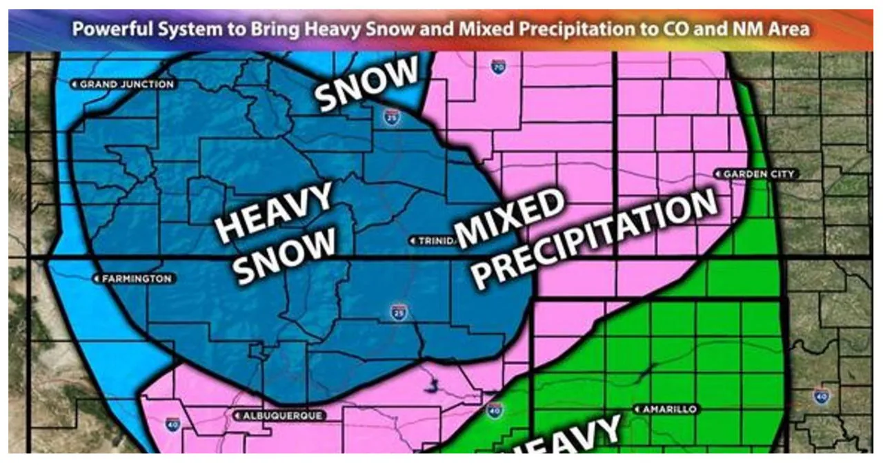
A powerful system is forecasted to sweep through the region, causing deteriorating conditions from Wednesday through Thursday. This system will result in widespread rainfall and heavy snowfall across various areas in Colorado, particularly the southern, southeastern, and southwestern regions. Additionally, the north-central, northeast, and northwest areas of New Mexico can also expect to experience the impacts of this system. The heaviest snowfall is anticipated in the north-central region. For further information, please see the details below.
The main impact of this weather system includes rain showers, heavy snow, and gusty winds.
Forecast Details:
As an upper-level low-pressure system moves eastward across New Mexico, it will bring warm moisture from the Gulf of Mexico into the areas of New Mexico and up to Colorado. This, along with the southwest flow ahead of the system, will lead to a concentration of flow aloft. As a result, there will be mixed precipitation before transitioning into heavy snow across the area, particularly on Wednesday night and Thursday. Additionally, there is a potential for freezing rain across the far eastern portions of Colorado, given the temperature fluctuations in that region. The initial rain showers will develop across New Mexico westward late tonight. Then, they will transition into snow showers across the central parts of New Mexico and south-central Colorado. Other areas, especially in eastern New Mexico and further south, will mainly experience rain showers, with a few heavy showers at times. The system is expected to move out of the area by Thursday night, and any remaining activity will subside by Friday morning. Wednesday afternoon also carries a risk of thunderstorms due to the instability levels, which could introduce the possibility of lightning, although it won’t be widespread.
The highest snowfall rates are predicted for north-central New Mexico and the southern part of Colorado. In these areas, snowfall totals could reach 6-8 inches, with some mountainous regions seeing over a foot of snow. Meanwhile, the southern and southeastern regions of Colorado are expected to receive around 2-3 inches of snow, with the possibility of higher amounts in localized areas.
Read More:
- Arkansas State Police initiates “Drive sober or face enforcement” campaign
- Severe Winter Storm Threatens Record Snowfall in Two States, Making Travel Impossible from Wednesday to Friday