How El Nio affects severe weather in December in Kansas City, U.S.
Several tornadoes were reported in Tennessee, Kentucky, Mississippi, and Alabama during the weekend. The National Weather Service estimates that 13 tornadoes touched down in Middle Tennessee, just outside of Nashville.
The National Weather Service in Nashville has been out evaluating damage over the last few days, and our Nashville sister station WTVF has been keeping up with the latest. The most powerful tornado so far is an EF-3 that touched down in Clarksville at 1:41 p.m. and unleashed 150 mph winds across a 600-yard width for an estimated 11-mile track.
Preliminary storm reports from US National Weather Service Nashville Tennessee indicate the following.
1. Long track tornado went through Clarksville with 150mph wind (EF3) & continued into Todd Co producing EF2 damage, likely connecting to damage near Bowling Green also.
1/2 pic.twitter.com/uhWkMuzypI
— Bree Sunshine Smith ☀️ (@NC5_BreeSmith) December 10, 2023
But how uncommon are cool-season tornadoes? The cool season is defined as November through February, and tornadoes during this time period prefer the Gulf Coast, accounting for 68% of all tornadoes in the United States from December to February.
Cool season tornadoes, however, are not limited to the Gulf Coast. When we look into tornado climatology (1998-2022) for the month of December, we can see that Missouri and Tennessee both see two tornadoes on average.
In December, the United States experiences an average of 43 tornadoes, with a preliminary total of 32 so far this year.
December Tornadoes
- 2022: 58
- 2021: 248
- 2020: 27
- 2019: 60
- 2018: 55
- 2017: 14
- 2016: 19
- 2015: 87
- 2014: 20
- 2013: 20
It should be noted that the year 2021 had the highest number of tornadoes in December in US history, with 70 tornadoes touching down, many of which were deadly. The year 2021 was also a La Nina year, and it is well known that El Nio and La Nina influence tornado climatology.
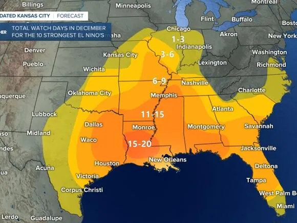
The cumulative number of December tornado watch days favors Louisiana, Mississippi, and Alabama during the top ten strongest La Nia occurrences (2011, 1998, 1971, 2007, 1999, 1970, 1988, 2010, 1975, 1973). During a powerful La Nia in December, we typically have two watch days in Kansas City.
But that is not the case this year; instead, we are retaining a Strong El Nino for the winter, which means an enhanced jet through the southern United States.
We tend to see more December watch days overall for the top 10 strongest El Nio events (2009, 1979, 2002, 1986, 1994, 1987, 1991, 1972, 1997, 1982) with the hot spot in a comparable area. The distinction here is that for watch days along the Mississippi River, there is a surge north.
This makes sense because our amplified strong track along the Gulf Coast will draw moisture from the Gulf and boost it north. With the perfect storm system in place, we might be fuelling more severe weather for folks in the Mississippi Valley and along the Gulf Coast. During the month of December, we typically have two watch days in Kansas City. So, for the month of December, the effect of La Nia vs El Nio doesn’t really amp up to quiet down severe weather concerns for us.
This winter has been unusually warm, with climate change playing a role. December is expected to be warmer than usual, with active weather persisting in the South.
Give it a few days & it will feel like Spring! There is some serious heat building into Canada (as temps read cold, they are actually 20°+ above norm by Thu). The US outlook for Dec could hold more warmth across the Plains & right now is tracking wet from KC to the Gulf. @KSHB41 pic.twitter.com/AY0WNLUavn
— ☀️ Cassie Wilson (@CassieKSHB) December 4, 2023
As the environment continues to warm, the frequency of days with severe weather is expected to rise. And the chilly season is no exception; according to Climate Central, “conditions favorable to supercells and tornadoes are expanding into historically less-active winter months.”
Read More:
- Gov. Ivey allocates over $46 million to assist low-income families in covering heating and cooling expenses
- The mobile cashier has been charged with organized retail theft