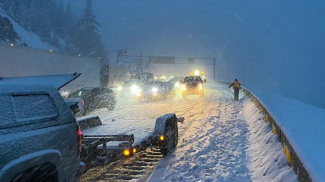
This weekend, heavy snow is expected on I-90 near the Washington mountain pass. What to anticipate
Residents in the Tri-Cities area who travel to the west side of Washington for Christmas shopping this weekend should be prepared for heavy snow and an icy combination of snow and rain in the Cascade Mountains.
From 10 a.m. Saturday to 10 a.m. Sunday, Interstate 90 at Snoqualmie Pass in the Washington Cascade Mountains is under a winter weather advisory.
The National Weather Service anticipates 5 to 9 inches of additional snow at the pass on Saturday.
An additional 3 to 5 inches of snow could fall early Saturday night before warming air transforms precipitation into a potentially slippery mix of rain and snow late Saturday night.
Precipitation is expected to fall as rain by early Sunday morning. Snoqualmie Pass is expected to receive half to three-quarters of an inch of rain on Sunday.
I-90 eastbound near Snoqualmie Pass was stopped Thursday evening due to multiple collisions and vehicles impeding traffic. Chains were needed.
I-84 Oregon forecast
Travelers on Interstate 84 east from the Tri-Cities may expect better driving conditions through Oregon.
Scattered snow showers were anticipated for Friday afternoon in Meacham, 30 miles east of Pendleton, in the Blue Mountains.
Saturday is expected to have a minor possibility of snow, with a rain and snow mix Saturday night. Wind gusts of up to 21 mph have the potential to push any new snow onto highways. The new snowfall should be less than an inch.
A half to three-quarter inch of rain is expected on Sunday.
Tri-Cities forecast
The Tri-Cities should expect another wet weekend, with an 80% chance of rain on Saturday and a 60% chance of rain on Sunday, with the majority falling in the morning. Both Saturday night and early Sunday, a tenth to a quarter inch of rain is probable.
The work week ahead should be overcast and dry.
Saturday through Wednesday, highs in the low to mid-40s are expected. Lows should range from slightly below freezing on Friday and Wednesday nights to above freezing on Saturday and Tuesday nights.
Read More:
- Three Percenters in Washington seek to shed ‘extremist’ label, but experts remain cautious
- Two Washington Lawmakers Champion Bills Aimed at Safeguarding and Expanding Hydropower Resources