
Storm intensifies: 50 mph wind gusts and scattered power outages are now expected in some areas
A severe, wide-spread storm accompanying the region’s current cold front is strengthening, with damaging wind gusts of 50 miles per hour and higher predicted to create sporadic power outages across most of the Northeast.
The enormous system came on Sunday afternoon, December 10, and will last through Monday, December 11.
According to the National Weather Service, sustained south-southeast winds of 25 to 40 miles per hour with gusts of 45 to 55 miles per hour are forecast through Monday morning, with greater gusts up to 60 miles per hour farther east and up to 70 miles per hour near the New England coast.
“At their peak, winds could gust to 50-60 mph in Boston and New York City, with higher gusts of 60-70 possible on Long Island and along the southern coast of Massachusetts, including Cape Cod, Nantucket and Martha’s Vineyard,” the National Weather Service said in a statement. “Damage or blow away of poorly secured outdoor objects is expected.”
The weather service warned that numerous tree limbs and scattered trees and electricity lines could be fallen, adding, “Expect poorly secured outdoor objects to be damaged or blown away.”
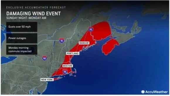
The areas highlighted in red in the first image above from AccuWeather.com are most likely to experience isolated power outages.
Rainfall totals of 2 to 4 inches are now forecast across the region, with locally higher totals of up to 6 inches likely.
From Sunday afternoon to late Sunday night, coastal areas are under a Flood Watch. It is probable to get localized flash flooding.
A High Wind Warning has been issued for eastern Long Island from 4 p.m. Sunday to 11 a.m. Monday, as well as for much of eastern Massachusetts from 10 p.m. Sunday to 10 a.m. Monday.
“Travel on the roads and around airports will be problematic, especially from late Sunday through Sunday night,” AccuWeather.com predicts.
On Monday morning, there is a chance of light snow with small accumulation throughout interior locations.
The day will be largely gloomy and breezy on Sunday. The risk of rain begins in the early afternoon, and the high temperature will be in the mid-50s.
On Monday, winds will change to the northwest early in the morning until the system moves out from the west to the east around midday, followed by progressive clearing and even some sunshine.
“Some rain will linger for the start of the day on Monday in New York City, with gusty winds and heavier rain lingering longer in Boston,” said AccuWeather Meteorologist Dean DeVore.
The passage of the cold front will bring cooler weather. Monday’s high temperature will be in the low 40s, with an overnight low in the upper 20s.
The weather for Tuesday, December 12 will be largely sunny and brisk, with a high temperature about 40 degrees.
The high temperature for Wednesday, December 13 will be in the upper 30s.
The forecast for Thursday, December 14 calls for mostly sunny skies and highs in the mid to upper 30s.
Read More:
- Powerful storm threatens Long Islanders with flooding and power outages.
- Authorities probe the death of a man discovered on the Bronx-bound 6 train